

FLOOD PROTECTION AND PREVENTION
Oshawa and Goodman Creeks
Two-Zone Floodplain Mapping and Flood Mitigation Update
Study Oshawa and Goodman Creeks
Central Lake Ontario Conservation (CLOCA) through a Watershed Flood-Risk Assessment (2017) identified an at-risk area upstream of the Canadian Pacific Railway subject to flooding within the City of Oshawa as shown in the figure. This flood hazard area has historically been managed using the two-zone concept. A specific policy has been in use for this two-zone concept area that provides direction on the type and form of development that may be permitted within such an area due to flooding constraints.
In 2019, CLOCA in association with the City of Oshawa, updated the Two-Zone Flood Policy and the associated mapping for the study area based on the update of the Floodplain Mapping completed by CLOCA in 2014.
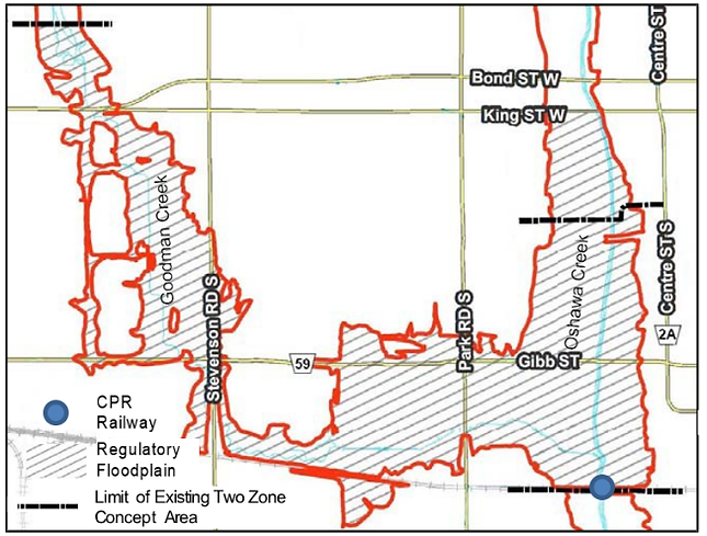
In general, the study re-defined the floodway and the flood fringe areas based on the most up-to-date floodplain information, re-examined possible mitigation options to alleviate flooding in the area and provided an impact assessment on future developments in the White Belt areas.
A Public Information Centre (PIC) was held Wednesday, September 25, 2019 at the Oshawa Civic Recreation Complex at 99 Thornton Road South, Oshawa. The PIC provided an information session for the public by presenting preliminary draft results and findings of the study, and an opportunity for public review and input.
The final Two-zone Floodplain Mapping and Flood Mitigation Study is provided below.
For further information about this study, please contact:
Lucy Benham, P.Eng.
Water Resources Engineer
Central Lake Ontario Conservation Authority
T: (905) 579 0411 ext. 106