WATERSHED MANAGEMENT
Lynde Shores Conservation Area Restoration and Resilience Plan
Great Lakes coastal wetlands play a critical role in supporting the freshwater ecosystem, the economy, and local communities. However, they are under serious threat from climate change and human activities.
Issues such as inappropriate development along the shoreline, changes in land use upstream, and the increasing frequency of severe weather events are negatively impacting these wetlands. Climate change is expected to make existing problems worse, including the loss of natural habitats, pollution, and the spread of invasive species. Data from Central Lake Ontario Conservation Authority’s (CLOCA’s) long-term monitoring programs show that climate change is already having a negative impact on the biodiversity and resilience of the wetlands.
Recognizing the severity of these challenges, CLOCA collaborated with Canada Water Agency (formerly Environment and Climate Change Canada) in 2024 to enhance the health and resilience of these crucial ecosystems and has developed a series of restoration projects to mitigate the threats facing the coastal wetlands of Lynde Creek Marsh and Cranberry Marsh located within Lynde Shores Conservation Area.
In addition to the $2.1M received from Canada Water Agency in 2024, CLOCA, in partnership with Ducks Unlimited Canada, secured $1.5M from the Province of Ontario's Wetland Conservation Partnership Program in 2026. These additional funds will be used to expand the restoration projects at Lynde Shores Conservation Area as well as complete the Westside Creek Wetland Restoration and Resilience Project.
Other funding partners include Ducks Unlimited Canada, the Region of Durham, and BGC Engineering.
Why Lynde Shores?
Canada Water Agency initiated a study to assess and enhance the resilience of Great Lakes coastal wetlands. That study aimed to understand vulnerability, develop adaptation strategies, and raise public awareness. Technical reports were produced by Canada Water Agency that focused on climate modeling (predicting future climate conditions), how wetlands will react, and how capable they are of handling changes. These findings provide important information for policymakers and others involved in wetland protection to help ensure these wetlands can survive in the face of climate change.
Through this study, the Lynde Creek Marsh and Cranberry Marsh Coastal Wetlands in Lynde Shores Conservation Area were found to be particularly sensitive and vulnerable to the impacts of climate change. The results showed that these wetlands could experience a decrease in biodiversity (the variety of plants and animals), resilience (their ability to recover from damage), and water quality. This is mainly due to changes such as the loss of certain types of plants, including submerged aquatic vegetation (plants that grow underwater), meadow marshes, and swamp habitats.
Additionally, more frequent and extreme changes in water levels are putting the wetlands at risk. These changes can disrupt interspersion—the mix and arrangement of different habitat types within the wetland—reduce the availability of cool-water refuges for fish, and harm the natural features that protect the wetlands. Low biodiversity makes these ecosystems even more fragile.
Data from CLOCA’s long-term monitoring programs show that climate change is already having a negative impact on the biodiversity and resilience of the wetlands. As a result of these findings, CLOCA, in partnership with Canada Water Agency, began working on strategies to help the Lynde Shores Coastal Wetlands adapt to these changes. The goal is to build their capacity to transform and survive over the long term, ensuring these important habitats remains healthy for years to come.
Restoration Goals and Objectives
The Lynde Shores Conservation Area Coastal Wetlands are diverse and resilient ecosystems whose natural features and functions are valued and protected for present and future generations.
Photo Credit, Mike Struna
Introduction to Lynde Shores Conservation Area
Lynde Shores Conservation Area is located in Whitby, Ontario, and stands as a premier attraction, regularly earning the top spot of Trip Advisor’s list of attractions in the Whitby area. Central Lake Ontario Conservation Authority estimates an annual visitation of approximately 200,000 individuals.
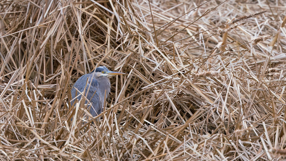
Walking and hiking trails, including the Great Lakes Waterfront Trail, are big draws for the area, with enthusiasts visiting from across the Greater Toronto Area. Additionally, Cranberry Marsh is a popular location for many photographers and watchers of bird and wildlife species, as the wetland supports a significant number of migratory birds, marsh-obligate nesting birds, raptors and wildlife species. With limited natural environments accessible to residents in the Greater Toronto Area, Lynde Shores Conservation Areas is a critical area for forest bathing, nature walks, mental health breaks, and exercise opportunities. Lynde Shores Conservation Areas is an accessible space that ensures inclusivity and caters to individuals of all ages and backgrounds, with its wildlife viewing offerings particularly popular among children.


The Projects!
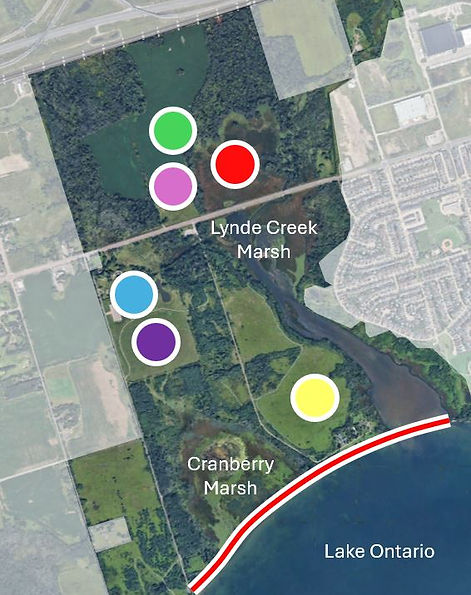
Wetland Interspersion Restoration: Restoration of the balance of open water areas in a monoculture of cattails.


Wetland Restoration
Wetland creation in historic wetland sites.


Climate Resilient Protective Wetland Features: Strengthening the barrier beach to maintain wetland separation.

Boardwalk Feature
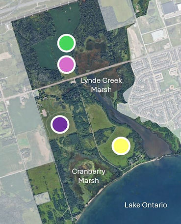
Google Earth, ©2024 Airbus (modification: faded area outside Lynde Shores Conservation Area, colourful circles, line and text overlay)
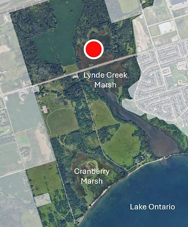

Wetland Interspersion Restoration
Project Summary: Creating channels and ponds within the dense cattail stands will establish open water areas that support a diverse range of fish, vegetation and wildlife. This balance of open water and plants will improve water quality, increase flood control, and enhance biodiversity.
The spread of hybrid cattails (a mix of native and invasive cattail species) and the way Lake Ontario’s water levels are managed have led to a significant loss of interspersion (the mix of open water and plants) in the wetlands of Lynde Creek. The area used to be a hemi-
marsh, meaning it had a healthy balance of water and vegetation, but now it has mostly turned into dense, single-species stands of Typha Glauca (a type of hybrid cattail). This has decreased water quality and reduced biodiversity (the variety of plants and animals), resulting in a loss of important ecosystem services—the natural benefits wetlands provide, like filtering water, controlling flooding, and offering habitat for wildlife.
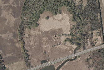
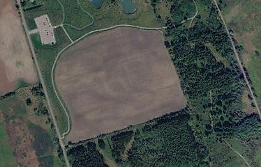
Before
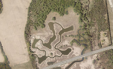
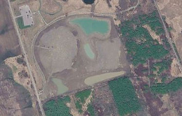
After
Restoring interspersion—bringing back the balance of open water and plant life—is critical for improving water quality, creating diverse habitats, and promoting bathymetry heterogeneity (variation in water depth, which supports different types of aquatic life). By carefully designing these areas, the wetlands will become more resilient to extreme temperatures, fluctuating water levels, and the more frequent and unpredictable changes in water levels caused by climate change. The result will be a stronger and more diverse ecosystem, rich in ecological and cultural value.
Wetland Interspersion Project Summary, Credit: A. Morrison


.jpg)
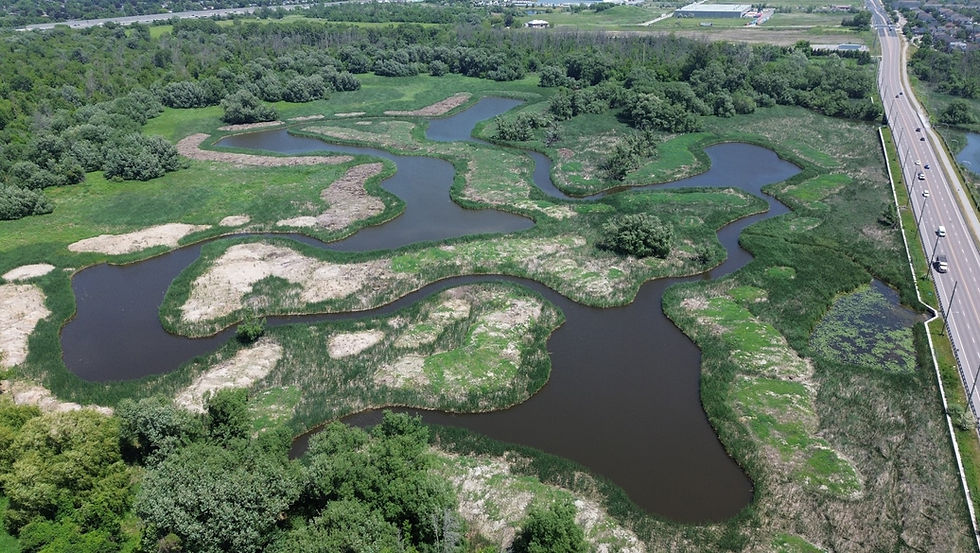
June 24, 2025
These aerial view faces east with Victoria Street on the right and show the digging progress over time. The digging for this project began on January 7, 2025, and was completed by the end of March 2025.
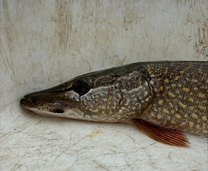
The digging for this project has been completed, restoring 39 acres (15.8 hectares) of wetland! A Northern Pike was caught and released in this newly restored area on May 8, 2025. Finding a pike less than two months after the draglines finished digging is an excellent sign! "Northern Pike is one of our target species for the Lynde Shores Restoration Project because Lynde Shores has been supporting very low numbers of them, and they are important indicators of wetland health," said Dan Moore, CLOCA's Senior Ecologist and Project Lead. By the end of July, 10 different species of submerged aquatic vegetation, including the carnivorous bladderwort and tape grass (not common in the Lynde Creek Marsh), were found in the restored area. Diverse plant life helps support a diversity of wildlife. Several schools of newly hatched fish were also spotted!
The mounds created from the digging were planted with native wetland plants and a cover crop of oats in the spring of 2025. The oats will not survive the winter, but serve to stabilize the soil so native wetland plants have more time to move in. Monitoring plants and wildlife, as well as more native plantings, are ongoing.
This project was funded by Canada Water Agency through The Great Lakes Freshwater Ecosystem Initiative. Thanks to Ducks Unlimited Canada for their support and consultative expertise, as well as Redpath Dragline Service for completing the work.

Wetland Restoration (Wetland Refugia and Adaptive Capacity)
Project Summary: New wetlands will be created, and existing wetlands restored or enhanced, to facilitate the migration of water as climate change drives rising water levels and more frequent storm events. Strengthening the landscape’s ability to adapt to fluctuating water levels through wetland creation will enhance flood control and provide refuge for wildlife during these environmental changes.
A large amount of wetland habitat has disappeared in Southern
Ontario over the last hundred years. This loss creates a serious challenge because wetlands are essential for helping ecosystems cope with climate change and for providing safe habitats for many species, including marsh-obligate nesting birds—birds that can only live and nest in marshes. This project aims to improve water quality, create more wetland refugia (a place where species can survive and persist during environmental changes), and increase the ability of wetlands to adapt by reclaiming areas that once supported wetlands, and enhance current wetlands, so they can survive future climate extremes.
With a climate-resilient design, the restored wetlands will meet the needs of migratory birds, shorebirds, amphibians, and many other species. By creating both large and small wetland areas with different water depths and controls over how water flows, we can ensure that these wetlands remain strong and healthy despite the challenges posed by climate change.
Halls Road Wetland Restoration
The Halls Road Wetland Restoration includes a large shorebird wetland habitat and two smaller wetland pockets for a total of six acres (2.4 hectares) of restored wetland habitat. From a flat farm field to a wetland complex with a viewing mound, the topographical transformation south of the main parking lot and Waterfront Trail at Lynde Shores Conservation Area will be completed in the summer of 2026!
Before
After

Photo from May 2026 with the Halls Road Wetland Restoration ninty per cent complete. An open channel that is part of the Lynde Creek Marsh is in the forground, connected with the Shisko Wetland behind it (piles for the new boardwalk visible on the left side). Beyond the Shisko Wetland are the three new wetlands of the Halls Road Wetland Restoration project, Cranberry Marsh, and finally, Lake Ontario. The new wetlands help link the exisiting Cranberry Marsh and Lynde Creek Marsh Coastal Wetlands.
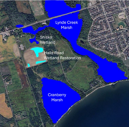
The existing wetlands (dark blue) will be better connected by the wetlands created through the Halls Road Wetland Restoration Project (light blue). Shisko Wetland was created in 2021 and directly connects with the large Lynde Creek Marsh. Maps Data: Google Earth, ©2025 Airbus (modification: dark blue and light blue polygon and text overlay)
These three new wetlands will provide additional areas of shelter for a variety of species as the climate changes. The new main wetland has a variety of depths, including deep areas where fish can find refuge from the heat and shallow areas for shorebird foraging. Some of these smaller wetlands will mimic vernal pools, which are temporary ponds important for amphibians like frogs and salamanders. Increased habitat diversity will support a wider variety of wetland plants, which will help improve water quality and further increase wildlife diversity.
The location of these new wetlands helps connect two important coastal wetlands: Cranberry Marsh to the south and the Shisko Wetland/Lynde Creek Marsh to the north. Connecting these large existing wetlands through a series of ‘stepping stone’ wetlands makes it easier for a variety of wetland species to move between the habitats. This allows for greater species diversity and increased genetic diversity within species, which results in greater climate change resilience in Lynde Creek Marsh and Cranberry Marsh.


By the end of January 2026, ninety per cent of the earth-moving component of the wetland restoration and viewing mound was completed. Topsoil placement began in June 2026, and the area was seeded with a variety of native wetland plants, including shrubs, trees, riparian vegetation (plants growing along the water's edge), and wetland meadow species by July 2026. These wetland plants will increase habitat diversity and contribute to better water quality, resulting in increased wildlife diversity. They will also improve the wetlands' ability to expand in the future.
This project was funded by Canada Water Agency through The Great Lakes Freshwater Ecosystem Initiative and the Region of Durham. Thanks to Ducks Unlimited Canada for their support and consultative expertise, as well as BGC Engineering for their in-kind contributions. Thank you, too, to VASQ Ltd. for their machines and expertise, and Tribute Communities for providing boulders and tree stumps that will be used to enhance the wetland habitat.
North of Victoria Street Wetland Restoration
Two separate wetlands will be created on the west side of the Lynde Creek Marsh Coastal Wetland. This area was historically part of the Lynde Creek Marsh Coastal Wetland, filled and managed as an apple orchard and later used as an agricultural field. Adding back these historic wetlands will help the Lynde Creek Marsh better adjust to varying water levels by increasing the wetland area during years with high water levels and providing safe, deeper areas for wetland animals during droughts.
Cell 1
This wetland will be directly connected to the Wetland Interspersion Restoration Project in the Lynde Creek Marsh Coastal Wetland. Central Lake Ontario Conservation Authority, Ducks Unlimited Canada, and Canada Water Agency worked together to develop plans for this project. Construction is planned from December 2025 - March 2026.
This project was made possible through the Province of Ontario's Wetland Conservation Partner Program and Ducks Unlimited Canada.
Cell 2
This second wetland will be separated from Cell 1 and the Lynde Creek Marsh. This wetland is nearing completion. The topsoil placement and native upland and lowland seed mixes have been applied (July 2026). Riparian plantings, additional native seed mixes, and upland woodland tree and shrub plantings will be completed in the fall of 2026.
This is a compensation project.
What is a compensation project?
CLOCA's planners and ecologists are often reviewing developments occurring near wetlands, shorelines and watercourses for the protection of people and property from flooding and the protection of the health of natural water systems. Occasionally, these natural heritage features can be compromised through the development process and despite best efforts to minimize impacts, the result is a compensation project, which involves the recreation of the natural feature in an area that will provide a net benefit to the watershed.


Eastbourne Wetland Restoration
The project will create approximately 8 acres (3.3 hectares) of new coastal wetland habitat on the west side of Lynde Creek Marsh. Like cell 1 in the North of Victoria Street Wetland Restoration Project, this wetland will be directly connected to Lynde Creek Marsh Coastal Wetland. A viewing mound connected to the existing trail system will be created with the excavated materials. The area was historically part of the Lynde Creek Wetland, but was filled for agricultural use. Adding back historic wetlands will help the Lynde Creek Marsh better adjust to varying water levels by increasing the wetland area during years with high water levels and providing safe, deeper areas for wetland animals during droughts. The project will create new coastal wetland habitat, improve hydrologic connectivity, enhance biodiversity, strengthen climate resilience, and provide opportunities for public engagement and recreation.
Central Lake Ontario Conservation Authority, Ducks Unlimited Canada, and Canada Water Agency worked together to develop plans for this project. This is one of the two additional projects made possible through the Province of Ontario's Wetland Conservation Partner Program.


Climate Resilient Protective Wetland Features
Project Summary: While further studies are required to determine detailed plans, the objective is to construct protective features that safeguard the barrier beach from continued erosion and damage due to high water levels, intensified storm events, and limited sediment supply.
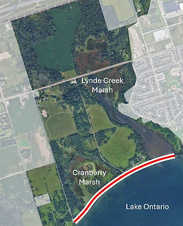
The barrier beaches in this area have been documented to be eroding at a rapid pace. Extreme storm events, less winter ice, and changes in coastal processes (including increased shoreline
hardening and the creation of piers which have disrupted the natural sediment flow in Lake Ontario) have collectively contributed to the risk of these important features disappearing. Without a protective barrier beach sheltering the wetland features from Lake Ontario, Cranberry Marsh would experience rapid, irreversible changes in water and habitat quality, resulting in a transformation that would undermine its ability to provide essential ecosystem services (such as filtering water and reducing flooding) and habitat for native species.
Through the implementation of nature-based solutions aimed at protecting and restoring the barrier beach, adverse impacts from high lake levels, intensified storm severity and compromised coastal process can be alleviated, ensuring the wetland thrives into the future. Central Lake Ontario Conservation Authority and our partners are working towards developing a design for the Cranberry Marsh barrier beach that will ensure this habitat remains a healthy and vibrant ecosystem.
There is a considerable amount of planning required to complete a project of this magnitude. The planning phase started in April 2025, with the goal of completing the project by March 31, 2028.
March 2026 Update
SJL Consulting coastal engineers have finished their first year of data collection, including current wind and wave forces, and have completed the initial analysis and modelling. Hindcasting data using orthophotos from the past sixty years revealed that the barrier beach has been consistently shrinking at a rate of 0.34 metres/year. The technical team has begun reviewing options for barrier beach protection focused on a range of concept designs with the understanding that CLOCA will prioritize nature-based solutions rather than shoreline hardening or artificial reefs. (Project 3 in the Lynde Shores Conservation Area Restoration and Resilience Plan).
This is part of the Lynde Shores' Resilience and Restoration Plan, funded by Canada Water Agency through The Great Lakes Freshwater Ecosystem Initiative and the Region of Durham. Thanks to SJL Consulting for their coastal engineering expertise.


Want to Learn More?
FAQs

Funding was generously provided under the Great Lakes Freshwater Ecosystem Initiative.