

WATERSHED MANAGEMENT
Improving Climate Resiliency of Oshawa Second Marsh
Restoration Project
aj groen
Great Lakes coastal wetlands play a critical role in supporting the freshwater ecosystem, the economy, and local communities. However, they are under serious threat from climate change and human activities.
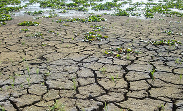
Issues such as inappropriate development along the shoreline, changes in land use upstream, and the increasing frequency of severe weather events are negatively impacting these wetlands. Climate change is expected to make existing problems worse, including the loss of natural habitats, pollution, and the spread of invasive species. Data from Central Lake Ontario Conservation Authority’s (CLOCA’s) long-term monitoring programs show that climate change is already having a negative impact on the biodiversity and resilience of the wetlands.
Recognizing the severity of these challenges, CLOCA collaborated with the Canada Water Agency (formerly Environment and Climate Change Canada) through The Great Lakes Freshwater Ecosystem Initiative to enhance the health and resilience of these crucial ecosystems and has developed a series of restoration projects to mitigate the threats facing several coastal wetlands, including Oshawa Second Marsh, Lynde Creek Marsh and Cranberry Marsh.
Why Oshawa Second Marsh?
The Canada Water Agency initiated a study to assess and enhance the resilience of Great Lakes coastal wetlands. That study aimed to understand vulnerability, develop adaptation strategies, and raise public awareness. Technical reports were produced by Canada Water Agency that focused on climate modeling (predicting future climate conditions), how wetlands will react, and how capable they are of handling changes. These findings provide important information for policymakers and others involved in wetland protection to help ensure these wetlands can survive in the face of climate change.
Through this study, Oshawa Second Marsh was found to be particularly sensitive and vulnerable to the impacts of climate change. The results showed that this wetland could experience a decrease in biodiversity (the variety of plants and animals), resilience (their ability to recover from damage), and water quality, mainly due to climate stressors, invasive species, pollution, and human activities.
Additionally, more frequent and extreme changes in water levels are putting the wetland at risk. These changes can disrupt interspersion—the mix and arrangement of different habitat types within the wetland—reduce the availability of cool-water refuges for fish, and harm the natural features that protect the wetland. Low biodiversity makes these ecosystems even more fragile.
The Improving Climate Resilience at Oshawa Second Marsh Project builds on years of CLOCA’s monitoring and research, and partnerships with organizations such as Ducks Unlimited Canada, Friends of Second Marsh, the City of Oshawa, and others. As the project lead, CLOCA received funding of $1.6M from the Canada Water Agency over the next four years through The Great Lakes Freshwater Ecosystem Initiative for the implementation of long-term restoration plans. Restoration efforts aim to protect and enhance both ecological values and the recreational and social benefits of the marsh.

Introduction to Oshawa Second Marsh
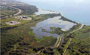
Oshawa Second Marsh is a 137-hectare, provincially significant, coastal wetland located in Oshawa, Ontario, and is the southern end of the Scugog Carrying Place Trail. It is currently owned by the City of Oshawa and supported by Friends of Second Marsh - a not-for-profit organization dedicated to its protection and appreciation. As one of 11 coastal wetlands in CLOCA's jurisdiction, Oshawa Second Marsh is naturally separated from Lake Ontario by a thin, dynamic beach known as a ‘barrier beach’, and has been monitored for decades within the Durham Region Coastal Wetland Monitoring Project and CLOCA's Integrated Watershed Monitoring Program.

Map showing the eleven coastal wetlands in CLOCA's jurisdiction with Oshawa Second Marsh circled in red.
In 2004, the marsh underwent a significant restoration project that involved rerouting Farewell Creek around the wetland in an effort to reduce upstream watershed impacts. This was mainly accomplished through a human-made dike/berm (see image below). A water-control structure combined with a carp exclusion barrier was installed in the dike approximately 500 metres upstream from Lake Ontario to maintain a small amount of hydrological connectivity between the creek/lake and the marsh. This allowed for the regulation of water levels in the marsh and access to the marsh by migratory native species like northern pike, while keeping out the invasive common carp. At the time of installation, a drawdown of the water levels was also achieved to mimic historical water level fluctuations, allow for the removal of common carp from the marsh, and encourage the reestablishment of aquatic vegetation by exposing the seed bank.
The carp exclusion barrier was vandalized in 2009, and the response of the native fish community in the wetland to the initial exclusion of carp in 2004 and the unfortunate reintroduction of the common carp in 2009 provided a unique opportunity to highlight the importance of carp exclusion for wetland restoration.


Aerial photograph showing Oshawa Second Marsh separated from Lake Ontario by a thin barrier beach. Also visible is the human-made dike that separates the marsh from Farewell Creek and the location of the 2004 carp exclusion barrier. McLaughlin Bay Marsh is also visible just east of Oshawa Second Marsh. The inset image was taken in the late 1970's and shows farmland surrounding the marsh as well as Farewell Creek emptying directly into the marsh (Photo credit: aj groen).

The Projects!


Phragmites Management
2025-2026
Project Summary: Control invasive Phragmites to improve native vegetative cover and wetland habitat quality.
Phragmites (Common Reed), is an invasive plant that spreads quickly and forms tall, dense stands. Phragmites crowd out native plants and reduce habitat for wildlife. Controlling this invasive species will restore space for native plants and create a healthier habitat for wildlife.

Barrier Beach Resilience Design
2026-2028
Project Summary: Collaborate with coastal engineers to develop a design that enhances the barrier beach’s resilience to water level fluctuations, storm events, and longterm climate impacts.
The barrier beaches in this area have been documented to be eroding at a rapid pace. Extreme storm events, less winter ice, and changes in coastal processes (including increased shoreline hardening and the creation of piers, which have disrupted the natural sediment flow in Lake Ontario) have collectively contributed to the risk of these important features disappearing. Without a protective barrier beach sheltering the wetland from Lake Ontario, Oshawa Second Marsh would experience rapid, irreversible changes in water and habitat quality, resulting in a transformation that would undermine its ability to provide essential ecosystem services (such as filtering water and reducing flooding) and habitat for native species.
Through the implementation of nature-based solutions aimed at protecting and restoring the barrier beach, adverse impacts from high lake levels, intensified storm severity, and compromised coastal processes can be alleviated, ensuring the wetland thrives into the future.
Hydrology/Wetland Water Level Improvements
2027
Project Summary: Restore more natural hydrology to improve wetland resilience and function.
Oshawa Second Marsh has benefited from past restoration efforts that were designed to address key threats and protect important wetland habitat. Over time, however, a combination of natural processes and earlier design choices—made to manage other risks—has reduced the movement of water between the marsh, nearby streams, and Lake Ontario. As conditions have evolved, this reduced hydrological exchange has limited the marsh’s ability to function as a fully connected coastal wetland.

Improving hydrological connections helps restore more natural wetland processes. Better water flow supports improved water quality, allows fish to move more freely between the marsh and the lake, and helps flush excess organic material from the system.
The goal is to restore three new hydrological connections between Farewell Creek and Oshawa Second Marsh that will allow for fish and wildlife movement while restricting carp access and allowing for water level management. These improvements will strengthen the overall health and resilience of the marsh, benefiting fish, wildlife, and the surrounding ecosystem.

Removal of Existing Pumping Infrastructure
2027
Project Summary: Decommission outdated pumps to reduce artificial water level manipulation and support natural hydrology.
The existing pumping equipment is not functioning and will be decommissioned and replaced with a modern, cost-effective system. The new infrastructure will allow water level management within the marsh, which will mitigate the effects of Lake Ontario water level regulation and support improvements to the vegetation community at Oshawa Second Marsh.

Interspersion and Bathymetry Restoration
2028
Project Summary: Create a natural mosaic of shallow and deep areas; restore bathymetric features to improve fish and wildlife habitat.
Restoring interspersion—bringing back the balance of open water and plant life—is critical for improving water quality, creating diverse habitats, and promoting bathymetry heterogeneity (variation in water depth, which supports different types of aquatic life).

Back in the sixties, Oshawa Second Marsh had healthy hemi-marsh conditions where open water areas were intermixed with wetland plants. Today, there are dense, monoculture stands of invasive Phragmites and Typha Glauca (a hybrid invasive cattail) where that hemi-marsh previously existed. The goal is to restore interspersion by digging out 475 metres of new channels and open water areas (light blue areas in the image on the left).
Sediment from upstream in the watershed has made the wetland shallow and uniform. Increasing the variation in water depth within Oshawa Second Marsh will allow for thermal refugia and increased habitat complexity.
By increasing wetland diversity both through restoring interspersion and bathymetry, Oshawa Second Marsh will become more resilient to extreme temperatures, fluctuating water levels, and the more frequent and unpredictable changes in water levels caused by climate change.
.jpg)
Dike Enhancements for Long-Term Protection
2028
Project Summary: Strengthen existing dikes to protect the wetland from extreme water level fluctuations and erosion.
The existing dikes will be strengthened to protect the marsh from erosion and extreme water level fluctuations. These enhancements are designed to improve long-term resilience to future high water levels, informed by climate change–based Lake Ontario water level projections developed by the Canada Water Agency.
Funding was generously provided under the Great Lakes Freshwater Ecosystem Initiative.


